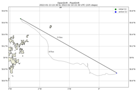
The ghost net was about 30 km north of Orkney and 70 south east of Shetland islands, and favourable sea currents could have brought the net ashore on either of these islands. There is a lot of shoreline in these islands, and many of them are uninhabited, but the net could have returned to civilization and someone might have even picked it up. However, the fate and sea currents made another decision, which took the net on a course towards south east, between Fair Isle and northern parts of Orkney. After that the net has been drifting mainly towards east, but unlike on the Norwegian coast, there has not been major storms in the area in January, which would have speeded up the journey of the net. The progress has been quite steady and more straightforward than during the first two weeks of January.
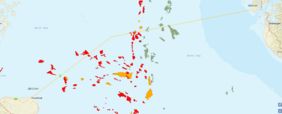
The net has moved towards an area, which sees a lot of fishing activity. There is a big fishing port in Fraserburgh on the coast of Aberdeenshire, so our ghost net is not the only one in the sea for sure. The net is now located about 200 km away from the spot where it was at the end of the first leg of its journey, approximately at 0.6 degrees East and 58.7 degrees North. It is in open sea, in an area, where there is also other kind of shipping activity. The net has drifted towards North Sea's oil and gas extraction area, and is about 200 km away from shores of Scotland a bit further away from the Norwegian coast. Supply ships, mainly from the offshore capital of North Sea, Aberdeen, transport provisions, equipment and tools to the rigs, everything that is needed to keep the extraction operations going. There is also some tanker traffic in the area, for instance to and from the oil terminal of Flotta in Scapa Flow, Orkney Islands, which is a major oil reception, processing, storage and export facility to the North Sea oil in British Isles.
The paths of the fishing boats, supply vessels or tankers might have already crossed with our ghost net, as it has made its way to its current location. But there is also a chance that the net will drift into an oil rig and get tangled into one, should it stay in the area. Whether we will come a full circle and our net returns to the source of the material, which is used to make them, or it will continue its journey, remains to be seen. We will find out that in four weeks...
On next week we will turn our focus back to the Baltic Sea and find out, where have the cigarette butts ended up, which fell in to the sea in the Archipelago of Turku. Stay tuned!


